how and why do the earth's tectonic plates move?
LO1: Recognise that the Earth's interior has a layered structure, that heat is generated at the core and that convection currents drive the movement of the plates.
Interpret a cross-section of the Earth with details of layered structure, using rock samples to contrast continental and oceanic crust.
the structure of the earth

The Crust
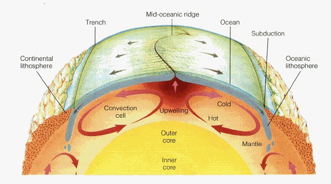
The crust of the earth is 5-50km thick. The top layer is the lithosphere which is broken up into plates. These move by convection in the plastic underlying asthenosphere layer.
The Mantle
The mantle is about 1,800km thick. The temperature ranges from 900-4,000°C. It is within the mantle that convection occurs.
The Outer Core
The outer core is 2,266km thick. The temperature ranges from 4,030-5,730°C. The outer core is molten iron.
The Inner Core
The inner core is solid iron and is 2,440km thick. The temperature is 5,430°C which is the same as the surface of the sun.
types of crust
There are two different types of crust:
|
Continental crust
Carries land Thicker than oceanic crust (up to 50km thick) Less dense Cannot be renewed or destroyed Cannot sink Old (most over 1,500 million years old) |
Oceanic crust
Carries water (the oceans) Thinner than continental (only 5km thick at some points) Very dense Can sink (subducted undernear continental crust) Can be renewed and destroyed New - less than 200 million years old |
student questionIdentify two differences between continental and oceanic crust. (2)
Identify and give details of the four layers of the Earth's crust. (8) What is the asthenosphere? (2) |
Lesson materials
|
Use this flipbook to give students a visual activity; they cut out the layers of the earth, stick them together and then add information about layers around the edge.
|
| ||
Examine the core's internal heat source (through radioactive decay) and how this generates convection, which drives plate motion and generates the Earth's magnetic field.
convection currents
Radioactive decay of materials such as Uranium occurs within the core and mantle of the earth and gives out huge amounts of heat. This heat causes molten rock in the asthenosphere to melt and become liquid magma. The heat created within the centre of the earth is moved to the surface by convection currents.
|
Convection currents
Convection currents are caused by heat being generated; hot magma rises towards the surface and cools. As it cools it sinks back down creating a cycle. The convection currents move the plates. Where convection currents diverge near the Earth's crust, plates move apart. Where convection currents converge, plates move towards each other. When the semi-molten rock reaches the surface it spreads out, moving the plates above along with it. |
LO2: To recognise that there are conservative, constructive and destructive plate boundaries, each with characteristic volcanic and earthquake hazards.
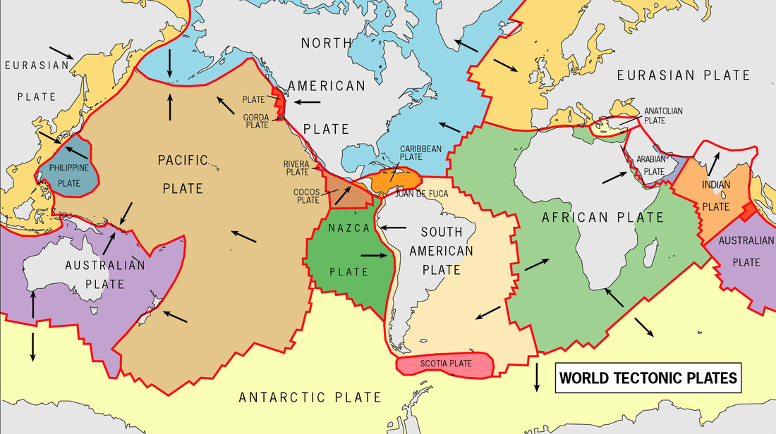
Explain the distribution of the three plate boundary types and identify major plates.
three types of plate boundary

1. Conservative Plate Boundary
This plate boundary is where two plates are moving past each other in opposite directions, or in the same direction at different speeds.
Friction gathers between the places; when the friction becomes too much the plates 'slip' in a sudden movement which causes an earthquake and produces shockwaves.
An example of this is the San Andreas Fault in California. Eventually (in a long, long time) Los Angeles will be further north than San Francisco due to being on the side of the fault which is moving northwards.
Conservative plate boundaries are sometimes also called a transformative or transform boundary.

2. Constructive Plate Boundary
A constructive plate boundary occurs where two plates move apart from each other. Magma moves upwards to fill the gap and solidifies creating volcanoes. This eventually results in new crust being forms.
An example of this is the Mid-Atlantic Ridge. The Mid-Atlantic Ridge is part of the longest mountain range in the world.
Constructive plate boundaries are sometimes also called divergent plate boundaries.

3. Destructive Plate Boundary
There are two types of destructive plate boundary.
3.1. Oceanic & Continental
The first type of destructive plate boundary occurs when oceanic and continental (or oceanic and oceanic) plates meet. The denser oceanic plate is forced down underneath the continental place. Heat caused by friction makes the oceanic plate melt. Magma rises up through cracks and erupts at the surface. Earthquakes can also occur in the subduction zone.
An example of an oceanic and continental destructive plate boundary is the Nazca plate being subducted under the South American Plate.

3.2. Continental & Continental
When two continental plate boundaries meet they form what is known as a collision zone. Both plates are equally dense and thus neither is forced underneath the other. They are therefore both forces up and create fold mountains.
An example of a collision zone with fold mountains is the Himalayas.
Destructive plate boundaries are sometimes also called Convergent Plate Boundaries.
lesson materials
|
Presentation on the three main types of plate boundaries including diagrams and examples.
|
Student activity - students draw a diagram of each plate boundary and complete the description task.
|
STUDENT QUESTIONS
Describe, with examples, the three main types of plate boundary and what happens at each. (9) What happens when two continental plates meet? (1) | ||||
distribution of plate boundaries and plates
|
STUDENT ACTIVITY
Students draw and label the major plates and plate boundaries on the blank world map. |
| ||
Examine the causes of contrasting volcanic and earthquake hazards, including tsunami at contrasting example locations e.g. Iceland and Indonesia.
There are methods which measure how severe or strong a natural hazard is...
|
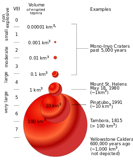
The Volcanic Explosivity Index (VEI)
This plots the magnitude of explosive eruptions from 0-8 in terms of explosivity. Each number is equal to ten times the one below it. |
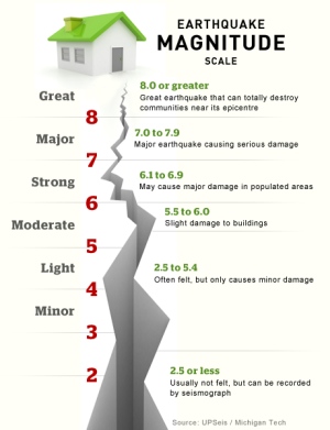
The Richter Scale
This uses a logarithmic scale to assess the magnitude of earthquakes. Those measuring 9 are ten times stronger than those measure 8 and so on. |
The Mercalli Scale
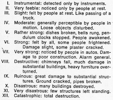
Used for measuring the intensity of an earthquake; explained in terms of the surface impact that different size earthquakes would have. |
|
|
|
|
Volcano Case Studies
Montserrat: measured 4 on the VEI. Was a composite volcano and the event was caused by the Atlantic Plate subducting underneath the Caribbean Plate. The explosion buried the capital in ash and caused half the population to leave the island. Laki (Iceland): Was the largest lava flow ever recorded; covered an area of 500 square km and measured 6 on the VEI. Did not have an elevated human impact due to the lack of human presence in the area. |
Earthquake Case Studies
Loma Prieta: Measured 7.1 on the Richter Scale; because the epicentre was shallow there was a lot of infrastructural damage on the surface and 63 people died. Asian Tsunami: An earthquake measuring 9.3 took place at a shallow depth underneath the Indian Ocean. A plate was displaced 40 feet causing a huge wave of water to move towards the land. Actual death total is unknown but estimated to be around 230,000 people. Importance of vulnerability should be considered by students. |
